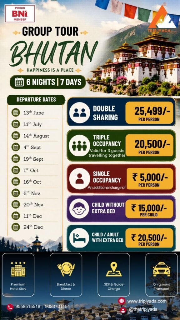


Day 1 - Guwahati Airport / Station → Shillong
Welcome to the Northeast — Your Adventure Begins
Route: Guwahati → Shillong (approx. 98 km | 2.5 to 3 hrs)
Your journey into one of India’s most extraordinary corners begins the moment your Tripjyada representative meets you at Guwahati Airport (LGB) or Guwahati Railway Station (GHY). The drive to Shillong climbs steadily from the Assam plains into the Meghalaya hills — and the transformation in landscape is almost immediate. The air cools. The roads begin to wind through dense forest. Pine trees replace paddy fields. By the time you reach the outskirts of Shillong, you already know this trip is going to be different.
Your first stop on the way into the city is Umiam Lake — a vast, shimmering reservoir cradled between forest-covered hills that many visitors mistake for a natural highland loch. It is the perfect place to step out of the vehicle, breathe the mountain air, and let the pace of the plains fall away completely.
On arrival in Shillong, check in to your hotel and freshen up. The evening is yours — and we recommend spending it on a slow walk through Police Bazaar, Shillong’s lively central market, where street food stalls do brisk business and the city’s famous rock music culture makes itself known from small venues tucked into side lanes. Dinner at a local restaurant introduces you to Khasi cuisine for the first time — and if you order the right things, it will not be the last.
- Overnight: Shillong
Day 2 - Shillong → Cherrapunji (with Dawki Excursion)
The Wettest Place on Earth and the Clearest River in India — Both in One Day
Route: Shillong → Dawki → Cherrapunji (approx. 130 km total | 4 hrs driving)
Today is the day Meghalaya announces itself at full volume — and it does so with a river that doesn’t look real, and a waterfall that drops off the earth.
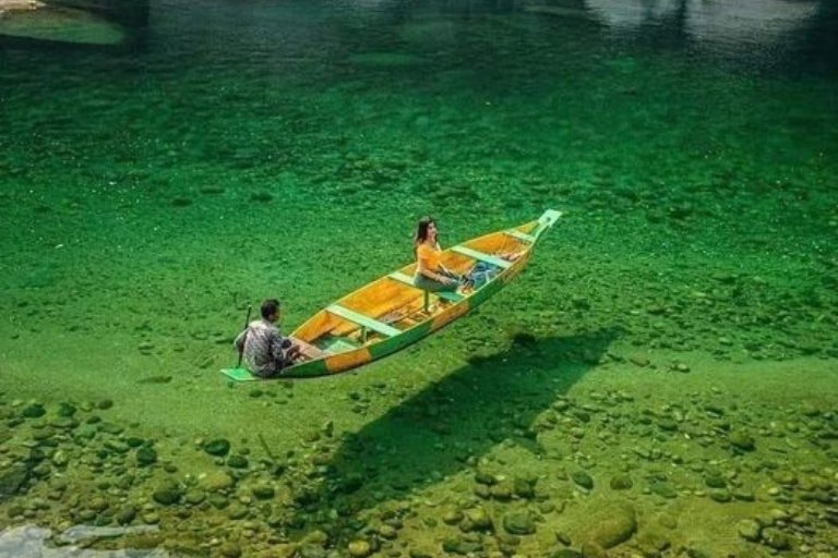
The morning begins with an early departure toward Dawki — a small border town where the Umngot River runs with a clarity so complete that boats floating on its surface appear suspended in mid-air above the riverbed below. This is not exaggeration or photography trickery. The water here is genuinely, impossibly transparent — and the slow boat ride across it, in the morning quiet with the Bangladesh hills visible on the far bank, is one of those travel experiences that people describe for years afterward and still feel their description falls short. Carry your camera. Expect to run out of storage.
After Dawki, the route climbs back up to the plateau edge and sweeps into Cherrapunji — officially one of the wettest places on earth and one of the most dramatically beautiful. The landscape here sits at the southern rim of the Meghalaya plateau, where the hills drop away suddenly into the Bangladesh plains far below and clouds pile up against the cliff face with theatrical regularity.
The afternoon at Cherrapunji is spent at two of its finest natural spectacles. Nohkalikai Falls — India’s tallest plunge waterfall at over 340 metres — drops in a single, breathtaking sheet off the plateau edge into a turquoise pool below. The viewpoint brings you close enough to feel the spray and understand the scale. Then the Seven Sisters Falls, named for the seven northeastern states, cascades across a wide valley face in multiple streams that merge at the base — a panoramic curtain of water that is best seen from the viewpoint as the afternoon light shifts.
Check in to your hotel in Cherrapunji. Dinner and an early rest — tomorrow requires both legs and determination.
- Overnight: Cherrapunji
Day 3 - Cherrapunji → Nongriat Trek → Shillong
3,500 Steps Down to the Most Extraordinary Bridge on Earth
Route: Cherrapunji → Tyrna → Nongriat → back to Shillong (full day)
Set your alarm early. Today is the day the tour earns its most enduring memory.
After breakfast, the drive to Tyrna Village marks the start of the most physically demanding and most deeply rewarding day of the entire journey. From Tyrna, the trail descends into the Nongriat valley via roughly 3,500 stone steps cut into the hillside — the forest grows denser and darker with every hundred metres of descent, the sound of water gets louder, and the outside world fades completely. This is Meghalaya at its most raw and most alive.
At the valley floor, the Double-Decker Living Root Bridge stands in quiet, ancient defiance of everything a modern mind assumes about construction. For centuries, the Khasi people have guided the aerial roots of rubber fig trees across river gorges — training them, year by year, into bridges that grow stronger with age rather than weaker. The Double-Decker at Nongriat is the finest example: two levels of interwoven living root spanning a river gorge, strong enough to carry dozens of people, extraordinary enough to stop every single one of them in their tracks.
After time at the bridge, follow the trail to the natural swimming pools nearby — cold, crystal-clear water tumbling over smooth boulders, ringed by subtropical forest with not a road or rooftop in sight. This is the swim that travellers tell their friends about.
The climb back up those 3,500 steps is real work — allow 2 to 3 hours for the ascent and pace yourself. It is worth every step.
Late afternoon transfer back to Shillong. Check in, clean up, rest well — you earned it.
- Overnight: Shillong
Day 4 - Shillong Local Sightseeing
The Rock Capital of India — At Its Own Pace
Route: Shillong city sightseeing (full day)
Today belongs entirely to Shillong — and Shillong, given a full day, reveals itself to be a considerably more interesting city than most first-time visitors expect.
The morning begins at Shillong Peak, the highest point in the city at 1,966 metres, where a clear day delivers a panoramic sweep of pine-covered ridgelines, valleys, and on the best mornings, a distant glimmer of the Brahmaputra plains far below. It is the definitive viewpoint of the city and the right place to begin.
From Shillong Peak, the route descends through the city to Elephant Falls — a beautiful three-tiered waterfall tucked into a green hollow on Shillong’s edge, where each tier has its own personality. The upper fall is wide and thundering, the middle narrower and more graceful, and the lower fall drops into a mist-filled pool surrounded by moss-covered boulders. A short, easy walk connects all three levels.
The afternoon opens with Mawphlang Sacred Grove — an ancient, protected forest held sacred by the Khasi community for centuries, where the trees, plants, and stones are preserved by tradition rather than law. Walking through it feels genuinely different from any other forest you have visited — quieter, older, more intentional somehow. A local guide explains the ecological and cultural significance of the grove in a way that stays with you.
The evening is free for exploration at Police Bazaar — Shillong’s commercial heart and the best place in the city for street food, local handicrafts, warm woollen shawls, and the particular pleasure of watching a hill town go about its evening at its own comfortable pace.
- Overnight: Shillong
Day 5 - Shillong → Bhalukpong
Crossing from Meghalaya into Arunachal Pradesh — The Adventure Shifts Gear
Route: Shillong → Guwahati → Bhalukpong (approx. 310 km | 7 to 8 hrs)
Today is a travel day — and a significant one, because by the time you reach your overnight stop you will have crossed from Meghalaya into Arunachal Pradesh, one of India’s most restricted, most beautiful, and most rarely visited states.
The morning departure from Shillong takes the highway back through the Meghalaya hills and down into the Assam valley, passing through Guwahati en route to the Arunachal border. The change in landscape as you cross into Arunachal is almost cinematic — the hills return, the roads narrow, the forests thicken, and the settlements become smaller and more widely spaced. This is frontier country, and it feels like it.
Bhalukpong sits at the base of the Arunachal hills on the banks of the Kameng River — a green, unhurried border town that serves as the gateway to the Tawang circuit. It is not a sightseeing destination in itself, but it carries a particular atmosphere — the sense of standing at the edge of something large and wild and beautiful that you are about to enter.
Check in to your hotel. The evening is quiet and the air is warmer here than what awaits in the mountains ahead. Rest thoroughly — the roads to Dirang begin climbing sharply tomorrow.
- Overnight: Bhalukpong
Day 6 -Bhalukpong → Dirang Local Sightseeing
Into the Heart of the Eastern Himalayas
Route: Bhalukpong → Dirang (approx. 140 km | 5 to 6 hrs via Sela Pass approach roads)
The drive from Bhalukpong to Dirang is one of the most scenically rewarding road journeys in northeast India — and it earns that description honestly. The road climbs continuously through forested mountain slopes, crosses the turbulent Kameng River multiple times on narrow bridges, and passes through landscapes of increasing drama as the altitude rises. Apple orchards begin appearing on the hillsides around Bomdila. The air sharpens. The peaks ahead grow taller and whiter.
Dirang is a small, gentle valley town at approximately 1,500 metres — warm enough for orange and kiwi orchards, enclosed by forested ridges on all sides, and carrying the quiet dignity of a town that has been a waypoint on mountain trade routes for centuries.
The afternoon sightseeing in Dirang covers several worthwhile stops. The Dirang Dzong — an ancient fortified village of stone houses clustered on a hilltop — is one of the oldest continuously inhabited settlements in Arunachal Pradesh and a remarkable piece of living history. The Sangti Valley, a few kilometres from town, is a broad, flat river valley of particular beauty that serves as a wintering ground for the rare Black-Necked Crane during winter months — one of the most sought-after bird sightings in all of India. The Dirang Hot Springs, tucked beside the river, offer a genuinely restorative soak after the day’s long drive.
The evening in Dirang is peaceful. The town goes quiet early, the stars are bright, and the silence of the mountain valley is the kind that allows a good night’s sleep.
- Overnight: Dirang
Day 7 -Dirang → Tawang (via Sela Pass)
Cross the Clouds at 13,700 Feet — Then Arrive at the Roof of Arunachal
Route: Dirang → Sela Pass → Tawang (approx. 140 km | 5 to 6 hrs)
If there is one drive on this entire ten-day journey that travellers consistently describe as the single most dramatic of their lives — it is this one.
The road from Dirang to Tawang climbs relentlessly through a series of switchbacks to Sela Pass at 13,700 feet above sea level — one of the highest motorable passes in the world and the gateway to the Tawang district. The landscape changes completely as the tree line is left behind and the road enters a world of bare rock, frozen lakes, and sky. Sela Lake, sitting in a bowl of ice and stone just below the pass, is an otherworldly sight — a perfectly still body of water surrounded by snow-streaked ridgelines and prayer flags that snap in the thin wind. The cold at the pass, even in summer, is immediate and bracing.
On clear days from Sela, the peaks of the Himalayan ranges stretch in every direction — a horizon of white summits that makes the scale of these mountains feel suddenly, physically real.
The descent from Sela into Tawang is equally dramatic — the road drops through a series of tight bends with sheer drops on one side and the green valleys of Tawang district opening below. Nuranang Waterfall (also called Jang Falls) thunders off a cliff face beside the road in a column of white water that is visible from kilometres away.
Tawang itself, arriving after all of this, feels like a destination that has been earned. Sitting at 10,000 feet, surrounded by mountains, and home to the second-largest Buddhist monastery in the world, it is a town unlike anywhere else in India — remote, spiritual, and genuinely magnificent.
Check in to your hotel. The evening view of the Tawang valley as the light fades is unforgettable.
- Overnight: Tawang
Day 8 -Dirang →Tawang Local Sightseeing
Ancient Monasteries, Sacred Lakes & the Edge of India
Route: Tawang city and surrounding sightseeing (full day)
Tawang deserves a full day — and today it gets one.
The morning begins at the Tawang Monastery, the spiritual centrepiece of the entire trip and one of the most significant Buddhist monasteries in the world outside of Tibet. Founded in the 17th century and sitting at the ridge above the town, the monastery complex houses several hundred monks, an extraordinary library of ancient Buddhist texts, a towering golden Buddha statue, and murals of exceptional artistry that cover the walls of its main prayer hall. The morning prayer session, if you arrive early enough, is one of the most moving experiences available on this entire route — the chanting, the incense, the butter lamps, and the scale of the monastery’s courtyard all working together to create something that lands differently for every person who experiences it.
From the monastery, the tour continues to the Tawang War Memorial — a striking modern monument built to honour the Indian soldiers who fell in the 1962 Sino-Indian War in these very mountains. The memorial is dignified and moving, and standing here with the Tawang valley spread below you gives context to the strategic and human significance of this remote mountain district.
The afternoon heads north toward Shungatser Lake (also known as Madhuri Lake after the Bollywood film shot here), a high-altitude glacial lake surrounded by snow peaks and rolling meadows that is one of the most photographed natural sites in all of Arunachal. The Bumla Pass, on the Indo-China border at 15,200 feet, can be visited by Indian nationals with the appropriate permit — a stark, wind-swept, historically charged landscape that stays with you.
The evening back in Tawang is for wandering the monastery town on foot — small shops selling thangka paintings, butter tea at a local cafe, and the particular quality of silence that only mountain towns at serious altitude possess.
Overnight: Tawang
Day 9 -Tawang → Bomdila (with Sightseeing En Route)
The Descent Begins — Through Apple Country and Ancient Monasteries
Route: Tawang → Bomdila (approx. 170 km | 5 to 6 hrs via Sela Pass)
The return journey from Tawang crosses Sela Pass once more — and if anything, seeing it from the opposite direction on a second crossing reveals details missed the first time. The morning light at the pass, when the peaks catch the early sun and the lake reflects a pale sky, is different from the afternoon crossing of two days ago and equally beautiful.
The road descends through the Bomdila valley, passing through apple and kiwi orchards that line the hillsides in neat rows and give this part of Arunachal a particular character — lush, productive, and quietly prosperous.
Bomdila sits at approximately 2,600 metres and serves as the administrative headquarters of the West Kameng district. The town is compact and pleasant, with a Buddhist character that reflects its geographical and cultural position between Tawang and the Assam plains below.
The afternoon sightseeing in Bomdila covers the Bomdila Monastery — a working monastery with a serene courtyard and good views across the surrounding valley — and the Craft Centre, where traditional Arunachali weaving and crafts are produced and sold. The Bomdila Viewpoint delivers a wide panorama of the valley below, with the plains of Assam visible on clear days stretching all the way to the horizon.
The evening in Bomdila is the final mountain night of the journey — quieter than Tawang, gentler in atmosphere, and carrying the particular bittersweet quality of a last night in the hills before the return to the plains.
- Overnight: Bomdila
Day 10 -Bomdila → Guwahati (Evening Flight)
One Last Mountain Morning — Then the Journey Home
Route: Bomdila → Bhalukpong → Guwahati Airport (approx. 270 km | 6 to 7 hrs)
The final day opens gently. A relaxed breakfast in Bomdila, a last look at the mountain ridgeline from the hotel window, and then the long drive down through the foothills toward Guwahati begins.
The road from Bomdila descends through the Kameng Wildlife Reserve — a protected forest corridor that is home to elephant, leopard, and a remarkable variety of bird species. The drive through this forest, with the river running alongside the road and the canopy closing overhead, is a beautiful transition between the high mountain world left behind and the plains world ahead.
At Bhalukpong, the route crosses back out of Arunachal Pradesh and into Assam — and the landscape flattens steadily as the road joins the highway toward Guwahati.
Arrive in Guwahati with time to spare before your evening flight. The city offers a final stop at the famous Kamakhya Temple if time permits — one of India’s most sacred Shakti Peethas, perched above the Brahmaputra on Nilachal Hill, its distinctive beehive-shaped dome and the sweeping river view from its courtyard making it a powerful final image to carry home.
Transfer to Guwahati Airport (LGB) for your evening flight — departing with ten days of mountain roads, ancient monasteries, glass rivers, thundering waterfalls, high-altitude passes, and living root bridges packed into memory.
- Departure: Guwahati Airport